
Poseidonis 23,180 BP
Hercules and the central sun
Aldebaran 40,000 and 430,000 BP
Celestial pole 70,000 BP
In The Secret Doctrine H.P. Blavatsky makes many references to Sampson Arnold Mackey’s work The Mythological Astronomy of the Ancients Demonstrated (MA), published in 1822-23 (Wizard’s Bookshelf, 1973). She sometimes calls it Sphinxiad (a zodiacal drawing in the book) or The Key of Urania (the title of part 2).
Mackey was a shoemaker by profession, but Blavatsky calls him a ‘very clever amateur astronomer’ and ‘the self-made adept of Norwich’ (see Sampson Arnold Mackey). His big idea was that the inclination of the earth’s axis (obliquity of the ecliptic) changes by about 4° every precessional cycle (25,920 years). The current tilt is 23.4° and is slowly decreasing. The north celestial pole therefore traces a spiral around the north ecliptic pole, each whorl of the spiral taking one precessional cycle. When the tilt of the axis becomes 0°, the celestial pole will coincide with the ecliptic pole, and will then start to spiral away from it again, and eventually invert through a full 360° (see Poleshifts: theosophy and science contrasted). Mackey interpreted many ancient myths and legends as referring to this phenomenon.
Blavatsky refers to Mackey’s discussion of Hindu legends about a lost island, known as White Island (Shvetadvipa/Śvetadvīpa) or Atala. Mackey identifies it with the island of Atlantis (or Poseidonis), which according to Plato was located in the Atlantic, beyond the Pillars of Hercules (Strait of Gibraltar), and sank about 11,500 years ago. Mackey writes:
... we consider the latitude and longitude of the lost island, and of the remaining Mount Az-burj. It was on the seventh stage of the world, i.e. in the seventh CLIMATE or MEASURE OF HEAT, which is between the latitude of 24 degs., and latitude 28 degs. north, and this White Island, which is called, also, Adbhi’-tanaya, or daughter of the ocean, is frequently described as lying in the west; and the sun is represented as setting at the foot of Mount Azburj to fight (scorch with his vertical beams) the White Devil or White Island. ...
In the above accounts the Hindus speak of this island as existing ...; it must therefore, have been more than eleven thousand years ago: and if we assume that time when the summer tropical colure passed through the Pleiades then would Cor Leonis [Lion’s Heart, i.e. Regulus] be upon the equator; and when Leo was vertical at the island of Ceylon at sunset, then would Taurus be vertical at the island of Atlantis at noon. We are informed in the A.R. [Asiatic Researches] that Ceylon was so called from singha, a Lion! And ... that the Ox [or bull] Nandi resided in the White Island. These are very remarkable occurrences which must have happened about 23,000 years ago: at which time the obliquity of the ecliptic must have been rather more than 27 degrees: and consequently Taurus must have passed over ATALA or ATALANTA.
But let us enquire after Mount Az-burj; at the foot of which the sun sets, &c. Az-burj is spelt various ways in the A.R. But they all may be reduced to ASH-BERI, a mine of fire ... A MINE OF FIRE is a proper epithet for a volcano; which may very well be denominated by a poet ‘a MONSTER VOMITING FIRE:’ and do we not all know that TENERIFFE is still remaining and in that latitude and longitude so often alluded to in the Hindu books? Teneriffe is in 28 degrees north latitude ... And its longitude, is such, that when the sun is vertical thereto, it is near the horizon of DELHI; and as Delhi and mount Az-burj or the peak of Teneriffe are in the same degree of north latitude; the ISLAND OF ATALANTIS, or the WHITE ISLAND to which it belonged must have been to the WEST of Delhi ... we are informed that the WHITE ISLAND has disappeared or sunk below the surface of the earth ... (MA, part 2, pp. 69-71)
In The Secret Doctrine (2:407-8), we read:
It was just remarked that since, in the Puranic accounts, the island is still existing, then those accounts must be older than the 11,000 years elapsed since Sancha dwipa [Shankhadvipa/Śaṅkhadvīpa], or the Poseidonis of Atlantis, disappeared. Is it not barely possible that Hindus should have known the island still earlier? Let us turn again to astronomical demonstrations, which make this quite plain if one assumes, according to the said adept [Mackey], that ‘at the time when the summer tropical “colure” passed through the Pleiades, when cor-Leonis would be upon the equator; and when Leo was vertical to Ceylon at sunset, then would Taurus be vertical to the island of Atlantis at noon.’
This explains, perhaps, why the Singhalese, the heirs of the Rakshasas and Giants of Lanka, and the direct descendants of Singha, or Leo, became connected with Sancha dwipa or Poseidonis (Plato’s Atlantis). Only, as shown by Mackey’s ‘Sphinxiad,’ this must have occurred about 23,000 years ago, astronomically; at which time the obliquity of the ecliptic must have been rather more than 27 degrees, and consequently Taurus must have passed over ‘Atlantis’ or ‘Sancha dwipa.’ And that it was so is clearly demonstrated.
Before assessing the astronomical statements made by Mackey and Blavatsky, we will first present some background information.
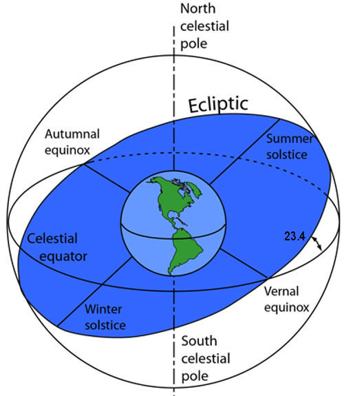
The coordinates of the stars as viewed from earth are continuously changing, due to the precession of the equinoxes, the shifting tilt of the earth’s axis, and their own motion through space.
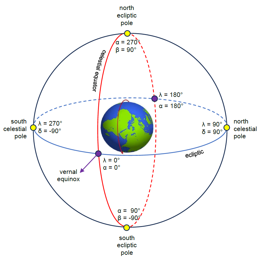
In the celestial/equatorial coordinate system, the latitude of a star is called declination (δ) and is measured north or south of the celestial equator (the projection of the earth’s equator into space). Celestial longitude is called right ascension (RA or α) and is measured eastward along the celestial equator from the vernal equinoctial point, one of the two points where the equator and ecliptic intersect. Right ascension can be expressed either in degrees or in hours, minutes and seconds, where 1 hour = 15°, and 24 hours = 360°.
In the ecliptic coordinate system, latitude (β) is measured north or south of the ecliptic, the plane in which the earth orbits the sun, and longitude (λ) is measured eastward along the ecliptic from the vernal equinoctial point.
The earth orbits the sun from west to east (anticlockwise) at the rate of just under 1° per day. As a result, the sun appears to move eastward through the 12 constellations of the zodiac in the course of a year. Due to the earth’s orbital motion, the stars visible at night from any particular location on earth change from one season of the year to the next.

As a result of precession, the position of the sun at the spring or autumn equinox and the summer or winter solstice shifts westward through the zodiac at an average rate of 50 arcseconds (1/72°) per year, taking 25,920 years to make a complete circuit of the zodiac.
The diagram below is a view of the celestial sphere looking down from galactic north. The earth is at the centre, with one half of it illuminated by the sun, and the other half in darkness. People located on the meridian at A are experiencing sunrise, people at B are experiencing noon, people at C are experiencing sunset, and people at D are experiencing midnight (bearing in mind that within the polar circles the normal succession of day and night does not always apply).
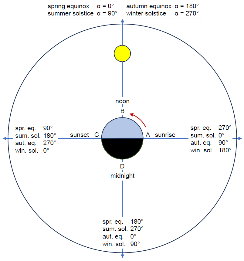
At noon (B) on the spring equinox, stars with a right ascension (α) of 0° will be aligned with our own meridian on earth. By the time of the summer solstice, the earth has moved 90° eastward along the ecliptic in its orbit around the sun. The summer solstice point on the ecliptic is therefore located at λ = 90°, β = 0°, which is also α = 90° (6h), δ = -23.4°. At the summer solstice, stars with a right ascension of 180° (12h) will cross our meridian at sunset (C), and stars with a right ascension of 270° (18h) will cross our meridian at midnight (D). If such a star has a declination equal to our latitude on earth, it will then be directly above our head (in our zenith).
Since Mackey’s book appeared in 1822-23, we will add 180 years to his figure of 23,000 years, giving a date of 23,180 BP (before present, meaning before 2000). The table below gives the calculated coordinates (rounded to the nearest degree) at that time of several important stars in Taurus and Leo, the constellations mentioned by Mackey. The calculations are based on the assumption of a 4° change in the earth’s tilt every 25,920 years, and an average rate of precession of 50 arcseconds per year, and take account of stars’ own motion relative to our solar system (see Stargazing and astronomical calculations).
Stellar coordinates 23,180 BP: Taurus and Leo |
||||
Star |
λ (°) |
β (°) |
α (°) |
δ (°) |
Alcyone |
98 |
4 |
99 |
31 |
Aldebaran |
108 |
-4 |
109 |
22 |
Algenubi |
179 |
10 |
184 |
9 |
Rasalas |
181 |
13 |
187 |
11 |
Regulus |
189 |
1 |
189 |
-3 |
Zosma |
198 |
15 |
203 |
5 |
Denebola |
212 |
14 |
215 |
-1 |
We will now consider each of Mackey’s statements in turn and show that they are all approximately correct.
1. In 23,180 BP the obliquity (ε) of the ecliptic was ‘rather more than 27°’.
ε = 23°26'21.448" (obliquity in 2000) + (4° x 23,180 / 25,920) = 27.02°
2. The solstitial colure passed through the Pleiades.
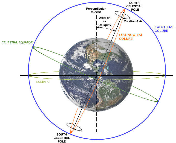
The solstitial colure is a great circle on the celestial sphere which passes through the celestial poles and the points of the summer and winter solstices. (The equinoctial colure passes through the celestial poles and the points of the spring and autumn equinoxes.)
In 23,180 BP the right ascension of Alcyone (the brightest star in the Pleiades star cluster) was 99° and its ecliptic longitude was 98°, close to the solstitial colure, which passes through α = 90° and λ = 90°. (The width of your clenched fist held at arm’s length is equal to about 10º, and the earth takes just over a day to move 1°.)
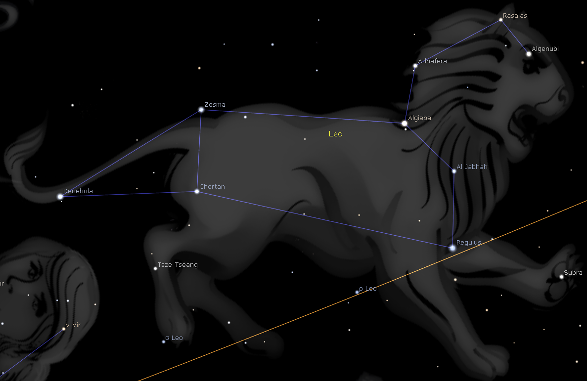
3. Regulus (Alpha Leonis) was on the equator.
Its calculated declination was just 3° below the celestial equator.
4. When Leo was vertical to Sri Lanka (Ceylon) at sunset, Taurus was vertical to Atlantis at noon.
Sri Lanka is located between latitudes 5.9° and 9.9°N, and any stars with a declination in this range will pass overhead in the course of the day or night. The declinations of the five stars in Leo listed in the above table (Algenubi, Rasalas, Regulus, Zosma and Denebola) range from -3° to +11°, so Leo would indeed have been vertical to Sri Lanka around 23,180 BP. The right ascensions of these stars at that time ranged from 184° (12.3h) to 215° (14.3h), which means that about four days after the summer solstice Leo would have begun to pass overhead at sunset, taking two hours to do so.
According to Mackey, the island of Atlantis is situated in the seventh climate zone, i.e. between 24° and 28°N. He links it to the Canary Islands (especially Tenerife), an archipelago of volcanic islands off the coast of North Africa, between latitudes 27.7° and 29.3°N, and believes it once extended from the Canary Islands to the Azores. There is an active volcano on Tenerife called Teide, which last erupted in 1909.
Around 23,180 years ago Taurus would have passed more or less over the island in the course of the day or night, because Aldebaran (Alpha Tauri) had a declination of 22°, and Alcyone (Eta Tauri) 31°. Since Alcyone had a right ascension of 99° and Aldebaran 109°, this would have happened at noon shortly after the summer solstice.
5. When the sun is on the horizon at Delhi, it is vertical at Tenerife.
Delhi and Tenerife are both located at about 28.5°N latitude, and Delhi is situated about 94° (6.3h) east of Tenerife. This means that when it is sunset in Delhi (i.e. the sun is on the horizon), it is noon in Tenerife (i.e. the sun is vertical).
According to theosophy, as our solar system orbits the centre of the Milky Way galaxy, it also revolves around a ‘central sun’ or ‘raja-sun’, located ‘under the thigh of Hercules’ (The Esoteric Papers of Madame Blavatsky, p. 660 (see quotation below); Blavatsky Collected Writings, 5:162-3).

Quotation from KH
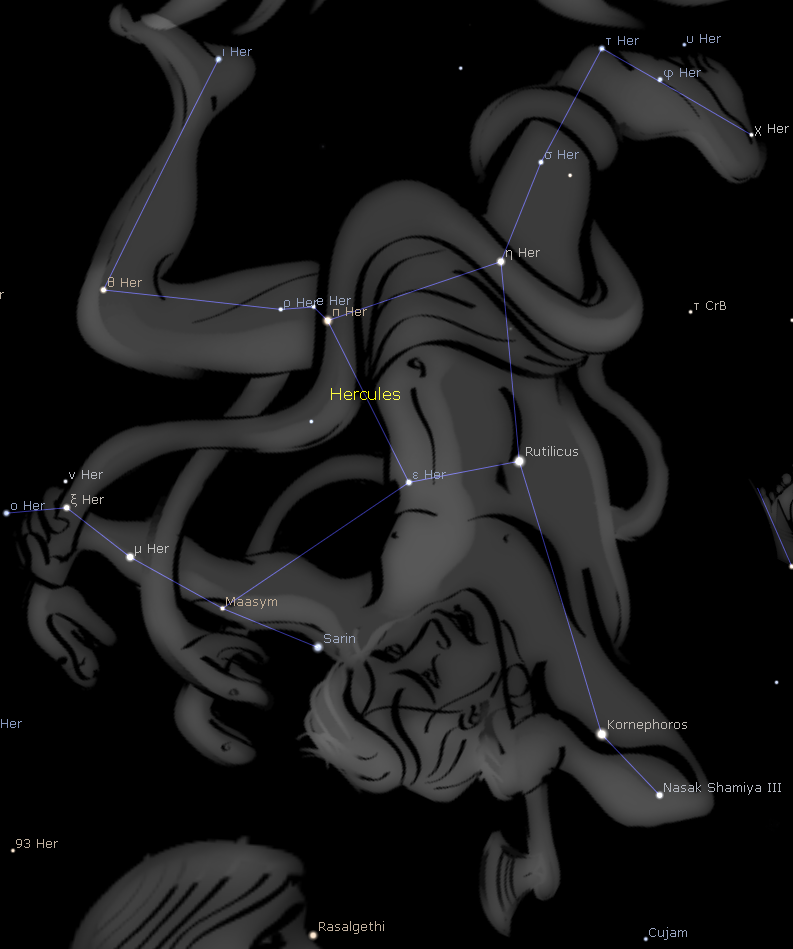
Frederick J. Dick states: ‘23,000 years ago, Cor Leonis was near an equinox, while the solstitial colure passed through Alcyone and the central Sun of our system, so that the Earth’s axis pointed towards the latter, at a distance of 27° from the ecliptic pole. ... ε and π are the stars in Hercules in the direction of which our central Sun is probably located’ (‘Studies in symbolism’, The Theosophical Path, 7:1, July 1914, pp. 26-33).
In 23,180 BP, Regulus had an ecliptic longitude and right ascension of 189°, close to the longitude of 180° where the autumn equinox occurs, so it was indeed ‘near an equinox’.
The solstitial colure intersects the celestial equator at α = 90° and 270°, and as shown in the previous section, it more or less passed through Alcyone 23,180 years ago. As for it passing through the central sun, the two stars that Fred Dick refers to had a right ascension close to 270°: 281° in the case of Epsilon Herculis, and 282° in the case of Pi Herculis.
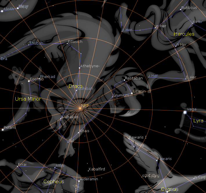
As for the earth’s axis ‘pointing towards’ the central sun, this may simply be another way of saying the same thing: that in 23,180 BP the central sun lay on celestial meridian 270°. The earth’s axis certainly did not point straight at the central sun at that time. The north celestial pole had the ecliptic coordinates: λ = 90°, β = 63°, and was located in Cepheus the King, about 3° from the two polestars: Errai (Gamma Cephei) and Pi Cephei.
Errai and (just to the right of it) Pi Cephei in relation to the north ecliptic pole (NEP) and Pi (π), Eta (η) and Epsilon (ε) Herculis.
Stellar coordinates 23,180 BP: Hercules |
||||
Star |
λ (°) |
β (°) |
α (°) |
δ (°) |
Pi Herculis |
291 |
60 |
282 |
34 |
Eta Herculis |
276 |
61 |
274 |
34 |
Epsilon Herculis |
287 |
53 |
281 |
27 |
Phi Herculis |
260 |
64 |
265 |
37 |
As noted, the central sun lies ‘under the thigh of Hercules’ (whatever that means). Pi Herculis is located in Hercules’ left thigh, and Eta Herculis in his right thigh, whereas Epsilon Herculis is located in his stomach. The above quotation from KH ends with the Greek letter phi (φ). This may refer to the star Phi Herculis, which is located in the lower right leg of Hercules.
The reason why Dick mentions the stars Epsilon and Pi Herculis is due to a ‘remarkable’ mathematical formula discovered by Euler: eiπ = -1. In this formula, e = 2.71828…, the base of natural logarithms (Euler’s number), and when raised to the power of i, the imaginary number (i.e. square root of -1), multiplied by π, the result is -1. Dick gives the following (rather contrived) explanation of this equation and its relevance:
Translated into English we might read it: a certain harmonical progression whirled at right angles gives rise to a retrograde motion. The ‘solar apex’ being to the east of the central Sun the motion is what is called retrograde in astronomy. The progression which forms the base of hyperbolic, or ‘natural,’ logarithms has the well-known symbol, e; the exponent i turns things through a right angle; π denotes the rotation, and -1 the retrograde revolution; while e and π are the stars in Hercules in the direction of which our central Sun is probably located!
A retrograde motion in astronomy means a clockwise (east-to-west) motion – the opposite direction to that in which the earth turns on its axis and orbits the sun. The solar system orbits the centre of the galaxy in a retrograde direction. It also appears to orbit the central sun in a retrograde direction, since the solar apex, the direction in which the sun is moving relative to local stars, lies east of the central sun.
Astronomers currently estimate that the solar apex is located in Hercules, near the border with Lyra, at approximately α = 270°, δ = +30°. Fred Dick suggested in a later article that the Great Pyramid was built in two stages, when the ascending passage, and later the Grand Gallery, were lying in the exact plane of the earth’s orbit, and that on the first of these two dates the earth’s axis was pointing to the solar apex (‘Ancient astronomy in Egypt and its significance’, The Theosophical Path, March 1916, pp. 287-303).
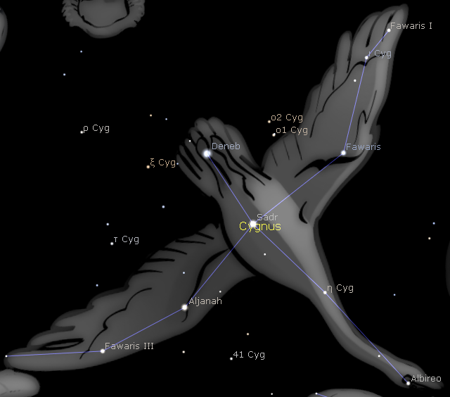
The ascending passage lay in the plane of the ecliptic 67,930 years ago, and the Grand Gallery lay in the plane of the ecliptic 66,375 years ago (Mysteries of the Great Pyramid, section 13). On the first of these dates the earth’s axis was pointing to within two degrees of the then polestar, Eta Cygni, in the neck of Cygnus, the Swan.

Eta Cygni is the circled star in Cygnus.
In The Secret Doctrine (2:785), Blavatsky writes:
… in the age when the gods forsook the earth and were said to ascend into the heaven, the ecliptic had become parallel with the meridian, and part of the Zodiac appeared to descend from the north pole to the north horizon. Aldebaran was in conjunction then with the Sun, as it was 40,000 years ago, at the great festival in commemoration of that Magnus Annus, of which Plutarch was speaking. Since that year (40,000 years ago) there has been a retrograde motion of the equator, and about 31,000 years ago Aldebaran was in conjunction with the vernal equinoctial point.
This passage is based on the writings of S.A. Mackey (MA, pp. 42-8). He argues that legends about the gods forsaking the earth and ascending to heaven refer to a time when the tilt of the earth’s axis was 90°, and the axis lay in the plane of the ecliptic. Blavatsky comments: ‘This is an ingenious explanation, even if it is not altogether free from occult heresy’ (SD 2:357).
When the axial tilt was 90°, the zodiac constellations were not seen close to the horizon as they are today, but around the great circle passing through the north and south celestial poles. In the course of a precessional cycle, the earth’s north pole would point to each of the 12 zodiac constellations in turn; some constellations will be seen to very slowly ascend towards the north celestial pole, while others will slowly descend towards the horizon.
The earth with an axial tilt of 90°, with its axis lying in the plane of the ecliptic. At the summer solstice in the northern hemisphere, the north pole points directly at the sun, and at the winter solstice the south pole points directly at the sun.
Mackey says: ‘It is more than 400,000 years since the Zodiac formed the sides of this ladder.’ If the earth’s axial inclination is declining at the rate of 4° every precessional cycle, then the inclination would have been 90° about 430,000 years ago. Mackey goes on to say that the Romans called Aldebaran Palilitium, meaning ‘ruler of festivals’, and adds:
This star was in conjunction with the sun 40,000 years ago, when they held their grand autumnal festival; from which circumstance, it is very likely to have been so called from the first; before they had observed the retrograde motion of the equator [i.e. discovered the precession of the equinoxes]. But, after a run of about eight or nine thousand years, it was found to be in conjunction with the vernal equinoctial point. This seems to have produced a new era in astronomy … (MA, pp. 47-8)
What does Mackey mean when he says that Aldebaran was ‘in conjunction with the sun 40,000 years ago’? At that time, the inclination of the earth’s axis was 29.6°, and Aldebaran had the following ecliptic coordinates: λ = 234°, β = -3°. In other words, Aldebaran lay virtually on the ecliptic, and was therefore ‘in conjunction with the sun’.
Mackey then says that, due to precession, Aldebaran was in conjunction with the vernal equinox some 8 or 9 thousand years after 40,000 BP, and Blavatsky says that this happened ‘about 31,000 years ago’. Calculations show that 30,920 years ago Aldebaran’s ecliptic longitude was 0°, this being the meridian that passes through the vernal equinoctial point.
Blavatsky goes a step further than Mackey and says: ‘Aldebaran was in conjunction then [i.e. 430,000 years ago] with the Sun, as it was 40,000 years ago …’ The calculated coordinates of Aldebaran 430,000 years ago are: λ = 67°, β = 70°, α = 278°, δ = 18°. If these coordinates are at all accurate, Aldebaran was not near the ecliptic at that time, but its celestial meridian (278°) did intersect the ecliptic close to the winter solstice point – the location of the sun at the winter solstice.
However, precessing star coordinates nearly half a million years back in time is subject to huge uncertainties. The calculations simply extrapolate the current three-dimensional motion of a star through space, as viewed from earth. But stars do not really have a uniform, linear motion in space with respect to our sun; rather, our sun and all other stars are following curved orbital trajectories within our galaxy.
A star’s ecliptic longitude is constantly changing, mainly as a result of precession but also as a result of the star’s east-west proper motion relative to our solar system. The ecliptic latitude of a star changes only as a result of the star’s north-south proper motion.
Aldebaran, a red giant, is located only 66.6 light years from earth, and its proper motion is larger than that of many other visible stars that are further away. The star is receding from our solar system at 54.4 km/s. In terms of its proper motion, it is slowly shifting southward, and also slightly eastward. Its current ecliptic latitude is 5.6° below the ecliptic. Its calculated ecliptic latitude 100,000 years ago is 2° above the ecliptic, so it was still part of the zodiac. Its calculated ecliptic latitude 430,000 years ago is 70° above the ecliptic, only 20° from the north ecliptic pole!
In Mythological Astronomy (part 2, p. 74), S.A. Mackey states: ‘It is 70,000 years since the pole of the earth pointed to the tip of Ursa-major’s tail!’
Compare this with what Blavatsky writes:
... there must have been a good reason why an Asiatic nation should locate its great progenitors and saints in the Ursa Major, a northern constellation. It is 70,000 YEARS, HOWEVER, SINCE THE POLE OF THE EARTH POINTED TO THE FURTHER END OF URSA MINOR’S TAIL; and many more thousand years since the seven Rishis could have been identified with the constellation of Ursa Major. (SD 2:768)
Note that Mackey says ‘tip of Ursa Major’s tail’ and Blavatsky says ‘further end of Ursa Minor’s tail’. Neither statement is correct.
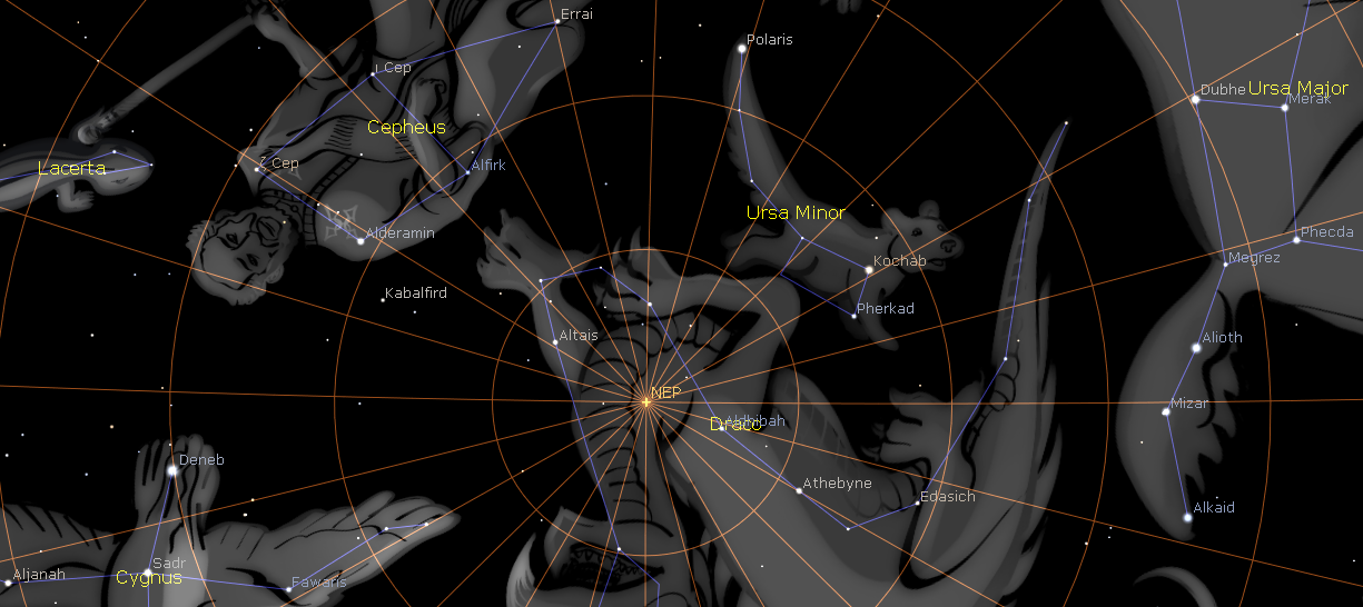
At present, the north celestial pole is located 23.4° from the north ecliptic pole, and 0.7° from Polaris (Alpha Ursae Minoris), which lies at the tip of Ursa Minor’s tail.
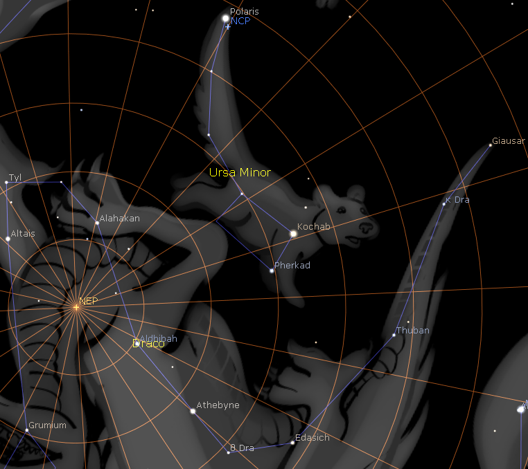
Polaris, the north celestial pole (NCP) and the north ecliptic pole (NEP).
Fred Dick initially took Blavatsky’s statement at face value, and concluded that 70,000 years ago the tilt of the axis was close to its present value, and about 77,760 years ago (exactly three precessional cycles ago) the north celestial pole was just over a degree away from where it is now, ‘at the extreme end of Ursa Minor’s tail’. This led him to believe that the axis undergoes a ‘swing’, with a period of 35,000 years, which ‘masks the main variation of four degrees per sidereal year’ (‘Studies in symbolism’, The Theosophical Path, 7:1, July 1914, pp. 26-33). He subsequently abandoned this idea, as we will see below.

Mackey’s statement that the earth’s north pole pointed to the tip of Ursa Major’s tail (i.e. the star Alkaid) 70,000 years ago contradicts his own hypothesis of a 4° shift per precessional cycle. The tilt would then have been 34.2° but the north celestial pole was nowhere near Ursa Major.
The diagram below shows the path of the pole during the period of a precessional cycle, assuming a constant axial tilt of 23.5°. Since a period of 70,000 years is equal to 2.7 precessional cycles, to determine the position of the north celestial pole in 70,000 BP we trace around the circle (clockwise) 2.7 times, starting from Polaris, and then move 10.8° (2.7 x 4°) further away from the ecliptic pole. This places the north celestial pole in the constellation Cygnus, on the opposite side of the ecliptic pole to Ursa Major (and Alkaid).
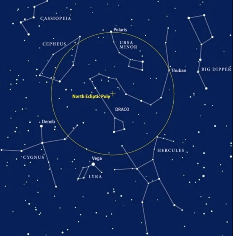
More precisely, in 70,000 BP the north celestial pole was located at λ = 90°, β = 55.8°, about 1.3° from Ksi (ξ) Cygni (λ = 88.3°, β = 56.7°), and 5.6° from the bright star Deneb/Alpha Cygni (λ = 83.0°, β = 59.9°).
At that time, the north celestial pole and Alkaid were both located the same distance (about 34°) from the north ecliptic pole, and were approximately 180 degrees of longitude apart (λ = 90° and 288° respectively).
As we’ve seen, Blavatsky not only writes ‘Ursa Minor’ instead of ‘Ursa Major’, but also writes ‘further end’ instead of ‘tip’. Fred Dick comments:
The word MINOR ... is a misprint for MAJOR. As to ‘the further end of Ursa Major’s tail,’ in the original sentence of The Key of Urania the words are, ‘the tip of Ursa Major’s tail.’ Mackey here made a slip of 180°. (‘Ancient astronomy in Egypt and its significance’, The Theosophical Path, March 1916, pp. 287-303 (p. 299fn))
The mahatmas helped with the writing of The Secret Doctrine, and undoubtedly had a hand in complex passages about astronomy such as these. It is impossible to know whether writing ‘Ursa Major’ instead of ‘Ursa Minor’ was a slip of the pen or a deliberate blind. As for writing ‘further end’ instead of ‘tip’, this could also be a slip of the pen or a deliberate attempt to indicate that Mackey himself had slipped up.
As Blavatsky says, it was ‘many more thousand years’ prior to 70,000 BP that the stars of Ursa Major were the polestars, the seven rishis being associated with the seven stars of the Big Dipper asterism. Calculations indicate that between 84,800 and 81,600 years ago several stars in Ursa Major (Alkaid, Alcor, Mizar, Alioth, Megrez, Dubhe) became in turn polestars, lying within about 5° of the north celestial pole. Alkaid lay closest to the north celestial pole around 84,275 BP, when its declination was 87.3°.
Poleshifts: theosophy and science contrasted
Mysteries of the Great Pyramid